Silver Training; day 2.

Low cloud and breezy, rain overnight, 12- 14°C

Making coffee from my little hiking tent. About 05.30am.


Day 2: relocate to another camp carrying full packs for about 7 miles over moorland. Staff carried full kit too as we are using the same campsites as the kids. The liked this camp better because of phone signal and no midges.The walk was long though, and galling for the kids I had; it began with a steep climb up Jacob’s Ladder. My 5 were very anxious about it and took several breaks going up.
Once on the Moor, we were in hill fog for most of the way.

Excellent, we can ‘walk on the compass’, pace and get therefore of finding markers on the route. In this case, the markers were lengths of slabbed path between boggy moorland. These girls hit the paths every time, it was working! That cheered me up after the misery expressed on the climb.

Eventually, we started a slow descent and came out of the cloud. Landmarks started to appear and the girls perked up.

On the turn, we encountered that group from a school in Hull. They seemed happy enough despite an error in Nav.causing considerable delay for them.
From this point, the day slowly brightened up and we started to dry out.
The campsite is nice, only marred by the farmer shooting to clear a wood of crows.
Rain blew in on the stiffening wind mid evening. Staff sheltered in the minibus.

Silver Training: Dark Peak.

Grey cloud at 800m, light wind but dry.

25 Year 10s on Silver training for 3 days in the Dark Peak area of the Pennines. This is much better training than we have done before, 3 days simulates their qualifying expedition more closely than other training ‘exercises’ we’ve run in the past.​

Venture onto Kinder Scout.

Day 1: onto kinderscout and return late. I took a nice group with a middle range of fitness. We let them put tents up and travelled with medium weight packs. The navigation was fine even on the Kinder plateau. It’s nearly featureless up there, so am excellent opportunity to teach some Nav. techniques. The tracks across the Moor and bog are not clear in the least.
We’ve dedicated 3 days of training for this group and it’s worthwhile that they have to acquire entirely new techniques compared to the mainly rural farmland they are used to.
On the last leg we crossed a group of girls from Hull doing their Silver Qualifying. They were almost at camp and some visibly exhausted. In contrast, others were quite upbeat. They chatted, they even said they disliked their accents. Sounded fine to me!
Delays meant we missed the gate so we took the road. It’s nice and easy to follow in the gloaming. Torches on at 10pm.
As soon as we arrived my group were horrified to hear that midges were there. This group were traumatised by midges a few weeks ago on bronze practice. None had midge nets. Some elected to cook near the barn and dive into bed later.
Some were hard to pervade to cook anything. So what if you have no appetite, that’s not why we’re eating tonight.

.

Bronze Assessment d.1

16°C bright and breezy.

White peak area: 92 girls on Assessment for Duke of Edinburgh Bronze Award.
We dropped them off at Ilam Hall just before noon. Their plan was to walk to Alstonefields for the night’s camp. They were given checkpoints that their routes had to pass through, but it was for the girls to plan and plot routes. The DofE mapping software can create an OS map printout and routecard with timings and leg distance calculated automatically. There were quite a few who handed in staff copies last minute. Others, I made them fix up impossible routes. Some had plotted paths that were parish boundaries not footpaths. One group mixed up their checkpoints and plotted a zig-zag route that totalled 19km. Our kids are very slow walkers anyway so wouldn’t make camp before dark on that route.

masterRoutecard

Master routecard that was used to start participants’ mapping. They had one of these 3 routes and plotted their own waypoints between the above checkpoints.

By noon, most groups had started fanning out on their chosen routes and us staff split up into small teams for remote supervision and assessing. I’m the only one who is qualified to go it alone which is what I did. After reading the kids’ routecards on the coach, I picked a route that crossed as many kids’ as possible. I kept on the move for the whole day on foot for flexibility.
The first group I met needed some help and then later some intervention. From 100m behind, I soon felt unhappy about their approach to a herd of cattle, cows and calves. The rule is ‘never between cow and calf’. Their approach wasn’t good, they may have crossed between cow & calf.
Anyway, after sorting then out, I set off on a parallel route and soon gained a kilometer. Good time for a lunch of sandwiches. They were baps with chilly-cheese and salad (in case you wanted to know).
Then the group mentioned above were spotted in a field attempting to cross the wall on the wrong side. Another intervention was necessary. I asked them about where they intended to go and which way the route should take them. They pointed about 180° from the correct way. After some some discussion and a few stern words, they set off east and I took the opportunity to repeat the 100m pacing exercise. They had all forgotten their stride counts, guessing from 10 to 100 for 100m. Oh dear, not encouraging.

Found this north of Thorpe Cloud beyond the shooting range. Though it looks like a railway tunnel, it’s smaller and contains nothing but rock. Above is an opening. I remain puzzled.
The next group I found were cheerful but considerably off track. At least they were heading the right way. Off they went north and I turned West to get to the gorge of Dovedale. A group down there were asking for staff to meet at a checkpoint at Ilam Rock. They wanted water. I had some, but concerned that they only got 2km at 5pm.I sent them off in the direction of their next checkpoint and went north to get more water; the idea was the catch them before the checkpoint.
Assessors agreed that they didn’t need to hit the checkpoint so I set off to catch them. They were rather relieved to hear this second change of plan.
Carl was there with a minibus which meant the end of my walk.

A mixed day for them. I clocked up 17km walking and got to groups that nobody in a minibus could have reached. Excellent for me and better for them too.

Another rescue.

24 – 18°C, warm, humid sun building mist to rain.
Thursday, another big day with DofE; this time, bronze Practice, and a year younger. Twice as many kids, less experience but first run, no fails.
I spent the whole day on foot by myself. I can be more useful that way. Mostly in radio contact so I had no difficulty intercepting groups. I used the day to catch 5 groups at checkpoints, although I am normally allocated to 3.
We issue checkpoints to all groups along with grid references. The girls plot their own routes freely as long as they make the checkpoints. I took a side route to the first. 3 groups pass Panner’s Pool and I relocate to meet them at the next one North. The big issue now is water. Many are only carrying 1 litre bottles, (despite instruction).
Then a call comes in, a following group reports a broken leg!

image

Midges, everywhere.


Emergency group: I go down on foot and Chris driver to the head of the valley. As I descend, I am able to ask questions about the condition of the group and their position. They obviously missed the turn and didn’t even see a large herd of black cattle. I had to ask about the direction of the sun, it’s obvious that they don’t have a sense of direction, nor can they use a compass.
Their voices sounded calm. Chris was descending, but I really wanted to get their first.
On arrival, the group were sitting at a derelict building and one girl had teary eyes. She had some tendon strain in her knees causing pain. No broken bones then.
The wellbeing of the whole group is now my concern. They are all dehydrated. So, once more, I gave them my water (I carry 3 litres).
Chris took the casualty’s rucksack and we headed up.
Easy and actually, fun.

Continue reading

Five get rescued.

24°C, light wind. Clear deep blue.
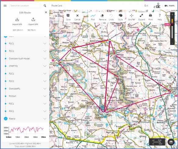
Duke of Edinburgh expedition, qualifying (retakes). Forty odd girls needed to re-take their expedition as a result of failing last year. Most had made a mess of navigation. All groups had most of the day to walk the 10km on low level rolling ground. Admittedly, there were tricky areas that need detailed navigation and other bits that simply need a longer steady trudge.
image

Most groups were at camp by about 8pm. Then a distress call came over the walkie-talkie radio at about 9pm. They were lost in woods that they had searched through for hours.
Chris and I decided to go find them and lead them back.
Up through the zig-zag path to the ridge we went. At the top, Chris went West, I went south-east. By now, the sun was down and we were desperate to get the girls off the hill.
The radio signal seemed clearer now, then a flash of inspiration; “girls, have you got a whistle?”. They had, so “give two quick blasts”
I heard it! I could pin-point the direction it came from. The Ridge was capped with Heather and grasses, below was dense woodland. They said they were on the edge of the trees so I told them to head uphill. My head-torch was set to red flashing. “Go uphill and aim for the red flashing light”.

“I can see you girls”, I called over the radio. Their whoop of delight was clearly audible without the radio. This was working. They were over 100m away but their torches were clear. “Careful and slow over the heather girls, there’s plenty of time”.
Heather can be horrible, depending on what they’re wearing.
Before light had completely gone, the first ones were on the ridge with me. By which time, Chris had arrived.
I headed down to help the last one who was struggling with her load.
One of them said, “never thought I would be so glad to see a teacher”. Big smiles with the relief. There they stood, with full packs but with shorts on this hot day. Their long, beautiful legs were criss-crossed with blood and scratches from the heather. Heather can be viscous, more when mixed with bramble.
They were happy to follow my plan- follow me down, I would lead and Chris takes the rear.
It must be after 10pm by now.
The return was fairly easy, just take the same route back. Once in the woods though, it was obvious how dark it had become. Those girls must have been quite frightened back there. Five young women, naive and inexperienced navigators had faced the possibility of a night on the hill.
I made sure lily walked behind me, but we should bunch together to pool the light. Only likely had a head-torch, the others carried hand torches that weren’t particularly bright.
To the right, I noticed the sound of deer amongst the trees, sometimes a bird would fly across the pathway, surely a tawny owl.

Shortly, Chris’s headlight gave up. It was the same one he used on that long night on Scafell over a week ago. Mine kept going.
It probably took 40′ to get back across the river. Across the river, the last part was easy. The camp was visible from there.

Continue reading

Hill and Moorland:3 (result).

6~ 8°C, light W. Sunny with only 1 shower.
it seemed to go well on the hill today. No mistakes and additional skills were cleared easily. The kit check was fine, I even showed off my water filter.
The tension of last night was relieved in this morning’s briefing. The assessor regarded my errors as repaired after I identified them.
So the day went ahead. My tension reduced. Until the hour before final debrief that is.
Last outing: north Carneddau again. Another rolling grassland, this is Hill and Moorland after all. My navigation legs were fairly easy and error free so I could relax and enjoy myself again.
image

Continue reading

HML assessment: day 2.

6°C, some sun to begin, snow after lunch turning heavy.

image
I’m starting to
enjoy myself now. My leads were ‘spot on’. Again, a couple of errors crept in while following. The Assessor thought my geology presentation was ‘enjoyable’. On the walk in, there was a fine piece of cut slate near a working quarry. On close inspection, it was peppered with iron pyrites. A nice piece.
Sunshine to start, later there were small hail stones pinging off our packs. In the last hour, snow fell. That reduced visibility as much as fog does, the grip is less too.
I have the feeling that when folks back at work ask what
I did go my holiday, they’re not going to be all that jealous.

Tonight is night walk. More micro-navigation but after dark. This rain should just about finish for an hour. I hope for no more snow, head-torches can work against you with bright reflections from larger flakes.
I can sense the possibility that I may just pass this.

Night walk…

Continue reading

Hill and Moorland Assessment:1

6°C, grey start with brisk W,
In a double room with a stranger, his name is Dave and he seems okay. I felt a little more than awkward. Kate last evening,
I introduced myself to two others in the bar. On their table saw their copy of the green book ‘Hillwalking’.
Meeting them did reduce my nerves somewhat.
image

Continue reading

Planning a hike.

Maybe next week:  Cadair Berwyn just beyond the Welsh border.
It’s approximately 800m high on a ridge with soft heathery slopes on the west and cliffs, opposite,
With luck, the weather will be terrible. Mist would be great, or blazing sunshine, either really. The sun brings colour, the mist brings interesting navigation.
I want to camp there for at least one night. I have never camped in February before.
Continue reading

A conclusion in Wales.

16°C, woke to rain, brighter by lunch.
It’s a shame to pack the tent away wet. Once decamped, a visit to Caffi Gwynant is the obvious thing to do.
As I have discussed here before,  I have a fascination for the Migneint. It’s a plateau (which was the centre of an ice sheet in glacial times). A rolling area of grasslands cut by meandering rivers. Last June, I checked out the start of a walk to the bothy near Arenig Fach.
The route started tricky, but is easy to navigate later. Strangely, the marked footpath deviates from the track on the map, but nothing was apparent on the ground. Simply walk along the track then!

image
This a fairly high altitude area, though it doesn’t look like that while there. These hills are between 400-500m, as high as the ridge I used for the last wild-camp. One clue was the fresh, cooler air.

The bothy was fairly typical, perhaps a little rougher than others. There was a newspaper from the 5th June on the table. The place was dirty and had few sleeping areas. Outside, the sides obviously used it for shelter although the door was well barricaded against them.
Not a very inviting place to stay, I’d prefer a tent. However, if you want a bad weather shelter, or you’re travelling light, this could be a solution. I would clean the place first thought.