DofE 10, Atherstone.

Chilly at night 7°C to about 12 in the days. Mostly dry.

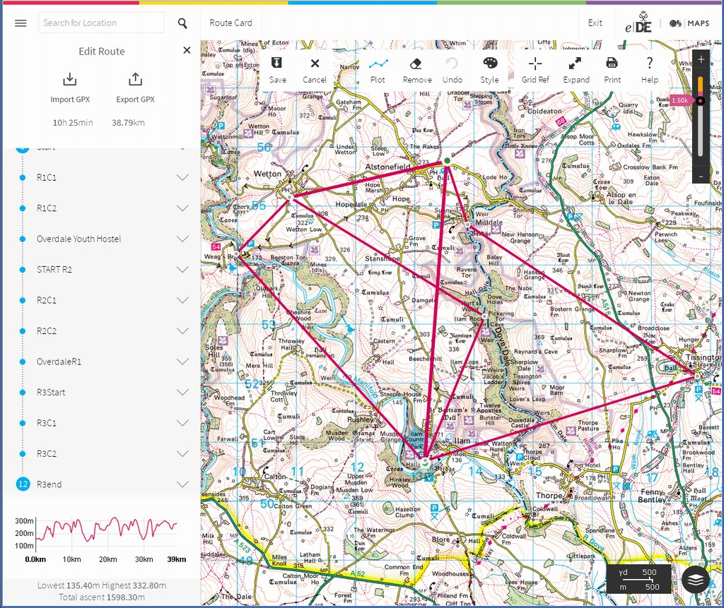
Day 1: The second group were cobbled together after spells on sepf-lockdown. There is a lot of this going on during this phase of the pandemic. Both groups have the same route but it was too short. Their route card had errors on some legs that were way out. So the kids were very early to checkpoints all day. The funny thing was the location. The villages around here are familiar from all this bike rides from Lichfield where I used to live.

Day 2: a day of drama. One parent had, apparently dropped off her daughter then driven home. They turned out from the campsite drive and then crashed. It was a head-on. The driver had asked us to keep this even from his daughter so she could get on with the expedition without worrying.

I went out to lead them over a blind humpback bridge. Ambulances and police cars shot over the bridge while an air ambulance circled. I didn’t find out till later what actually happened.

It wasn’t untill the end of the job that I heard what happened with that crash. Spoiler alert – nothing.

DofE 7 & 8: Princethorpe Qualifying expedition.

23°C, light breeze and bright sun.

Camped at the same site as in July; the campsite the expedition is using is rather tatty. The showers still have an Out Of Order sign, even 2 years after the first time I visited.

Group A, 5 lads. A group I’ve met before who got on well and had no difficulty at all. It was warm and sunny both days. The plan is to walk with them for part of day 1 and check their competance. I ended up leaving them later than ideal because there was a risky road section further on that I wanted to escort them down. As it turned out, the road was held in check by HS2 works a few miles down.

A long checkpoint on by a grassy verge. I was there about an hour, enough time to brew a coffee and get the tent dry. I guy walked past and asked if I was ‘doing a spot of wild camping?’. I answered him politely, he seemed to have little knowledge of what that entails.

Group B, a week later… 6 girls this time. More fine September weather and a very able group. They only made mistakes near lunchtime when they got hungry. I could see their confidence inproving over the hours I walked with them. As last week, I left them slightly earlier to get my car for a few final checkpoints. They travelled safely enough but had rather more rest-stops than is ideal.
Group 14 arrived at camp last and were determined to prove their ability to erect tents AND cook in the short hour remaining before pickup.

Unfortunately for both trips, they couldn’t camp the night because of Covid-19 restrictions. Many kids see camp as the highlight of the expedition- it’s a time to relax, look back on the day and for many – stay in a tent for the first time. It’s a shame they miss out on their first camp.

Bronze d2.

Grey and breezy. 14C.
Started near the day’s end checkpoint. My job is to patrol the drover’s paths and pick up any strays. It’s an easier day for me, good because I’m now getting tired. 17km walking yesterday and 77 miles on the bike Sunday. It adds up you know.​

Fallen tree in Biggin Dale.

 If I can keep it under 8 miles today, I can recover.
In contrast to yesterday, the bronze groups got through their routes much faster. We were left with time to kill at the visitor centre. So cups of tea were drank and tents laid out in the sunshine to dry. If they’re dry, the kids don’t have to take them home to dry. Win-win.

Bronze Assessment d.1

16°C bright and breezy.

White peak area: 92 girls on Assessment for Duke of Edinburgh Bronze Award.
We dropped them off at Ilam Hall just before noon. Their plan was to walk to Alstonefields for the night’s camp. They were given checkpoints that their routes had to pass through, but it was for the girls to plan and plot routes. The DofE mapping software can create an OS map printout and routecard with timings and leg distance calculated automatically. There were quite a few who handed in staff copies last minute. Others, I made them fix up impossible routes. Some had plotted paths that were parish boundaries not footpaths. One group mixed up their checkpoints and plotted a zig-zag route that totalled 19km. Our kids are very slow walkers anyway so wouldn’t make camp before dark on that route.

masterRoutecard

Master routecard that was used to start participants’ mapping. They had one of these 3 routes and plotted their own waypoints between the above checkpoints.

By noon, most groups had started fanning out on their chosen routes and us staff split up into small teams for remote supervision and assessing. I’m the only one who is qualified to go it alone which is what I did. After reading the kids’ routecards on the coach, I picked a route that crossed as many kids’ as possible. I kept on the move for the whole day on foot for flexibility.
The first group I met needed some help and then later some intervention. From 100m behind, I soon felt unhappy about their approach to a herd of cattle, cows and calves. The rule is ‘never between cow and calf’. Their approach wasn’t good, they may have crossed between cow & calf.
Anyway, after sorting then out, I set off on a parallel route and soon gained a kilometer. Good time for a lunch of sandwiches. They were baps with chilly-cheese and salad (in case you wanted to know).
Then the group mentioned above were spotted in a field attempting to cross the wall on the wrong side. Another intervention was necessary. I asked them about where they intended to go and which way the route should take them. They pointed about 180° from the correct way. After some some discussion and a few stern words, they set off east and I took the opportunity to repeat the 100m pacing exercise. They had all forgotten their stride counts, guessing from 10 to 100 for 100m. Oh dear, not encouraging.

Found this north of Thorpe Cloud beyond the shooting range. Though it looks like a railway tunnel, it’s smaller and contains nothing but rock. Above is an opening. I remain puzzled.
The next group I found were cheerful but considerably off track. At least they were heading the right way. Off they went north and I turned West to get to the gorge of Dovedale. A group down there were asking for staff to meet at a checkpoint at Ilam Rock. They wanted water. I had some, but concerned that they only got 2km at 5pm.I sent them off in the direction of their next checkpoint and went north to get more water; the idea was the catch them before the checkpoint.
Assessors agreed that they didn’t need to hit the checkpoint so I set off to catch them. They were rather relieved to hear this second change of plan.
Carl was there with a minibus which meant the end of my walk.

A mixed day for them. I clocked up 17km walking and got to groups that nobody in a minibus could have reached. Excellent for me and better for them too.