14°C, rain all day. Some heavy.
late start with much to do in the morning. It turned into a QMD. I stopped the clock at 6h 50m.when I got back to the minibus.
late finish but not as bad as last night.
Carl and I dropped the Silver trainers off and I set off to Pen-y-Fan summit to intercept the two Gold groups. Incidentally, I had a fright on the way up when my map blew away. Fortunately, I had the bag off at the time and could set off in rapid pursuit. It hadn’t gone very far, much to my relief.
The summit was easy enough with a sandstone staircase for the last bit. There is a substantial cairn at the top with a plaque.
Other schools were using the ridge for their Gold Practice runs too. Group after group headed east from an independent Girls’ school near London. They seemed so confident and upbeat in the harsh weather. One of their guys on the checkpoint thought he’d seen a group of four go by so after sandwiches, I headed east. I was quite anxious that I’d miss them and it would be a wasted journey when Carl might have appreciated help with the training group.
Behind Cribyn, I found them. They were happy but cold. Only 2 had gloves, 1 a hat and 3 no waterproof trousers. Abi was especially cold in her cotton tee-shirt. Lend out 2 pairs of gloves and a merino base layer to them. I was so pleased to see them and be able to help out.
This gold group thought that the other Gold group can’t be far behind. Two of those had packs weighing in at 20kg which made their likely position beyond the first summit. So, off I went.
The phone rang to say that Gold group 2 weren’t even on access land. They had problems. It was better for me to intercept one of the Silver groups approaching Fan-y-Big. About turn and go east again!

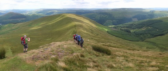
Silver Practice group’s first ever mountain summit.
This silver group were on the Bwlch before Fan-y-big and in good condition. Not far in front, Gold were on the summit so I could catch them. From a distance, they were visible in the hill fog making the correct descent near cliffs in the mist. A very capable group, apart from their kit.
Both groups made good descents once I’d finished the photo shoot.
Once again, I marched west, this time to catch the 2 Silver training groups on Pen-y-Fan. However, they’d returned forcing me to find a route down on the next ridge. there is a fabulous path across the north face of Cribyn.