DofE 16.0

15°C falling to 0°C under clear sky.

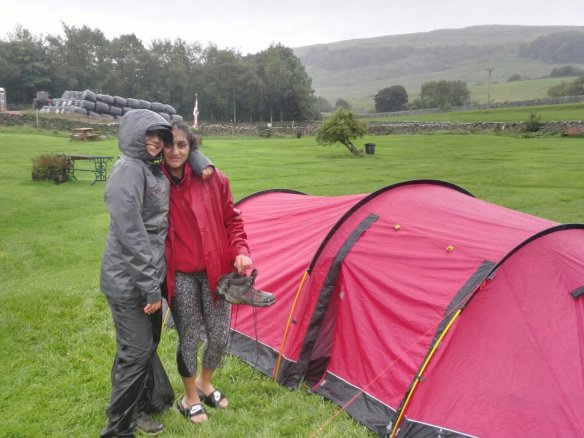
Gold Qualifying expedition, Brecon Beacons. Long drive in fine conditions, rolling mist filled some fields near the coast. That reminded me of some of the early season trips this year. In in the tent now as the air rapidly approaches freezing. It’s going to be a cold one! I met my two groups earlier and they seem lovely.

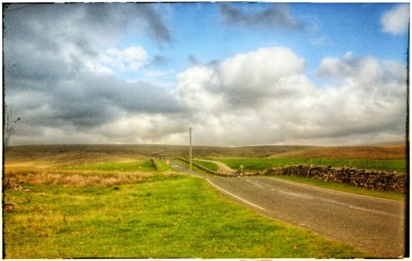
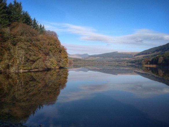
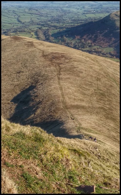
DofE 16.1 Friday: sorting out a lad who woke feeling and looking rather ill took so much time this morning. He was so pale, he looked almost green. I was ready to pull him out and the other staff agreed. The school wanted to try warming him up and persuade some food into him. Their approach turned out to be right. After the warm minibus ride to the start point, they set the group towards an old railway line. My plan was to drive to a point half way, walk in and intercept the trail on foot. The valley held a temperature inversion, fog pooled in the bottom like a sheepskin rug. It was very dense once you descend into it, cold too. It did burn off quickly, a photo opportunity missed, I can’t stop when I’m working. It took too long to decide on a parking spot. This area has a terrible reputation for car break-ins.

I got up there and saw no groups. Even walking a few km SW revealed nobody. That’s good really because he must be okay. So, off to the next checkpoint after walking for about 4km.

In the evening we inevitably cooked in the dark, no problem with that. The nearby woods attracted the most tawny owls I have ever hear in one go, at least five. There was a barn owl calling in the valley too. Another call in the mix I didn’t recognise, the night sky is clear too.

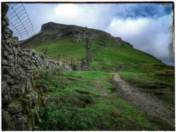
DofE 16.2: Fan-y-Big and Cribyn.

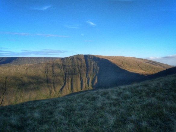
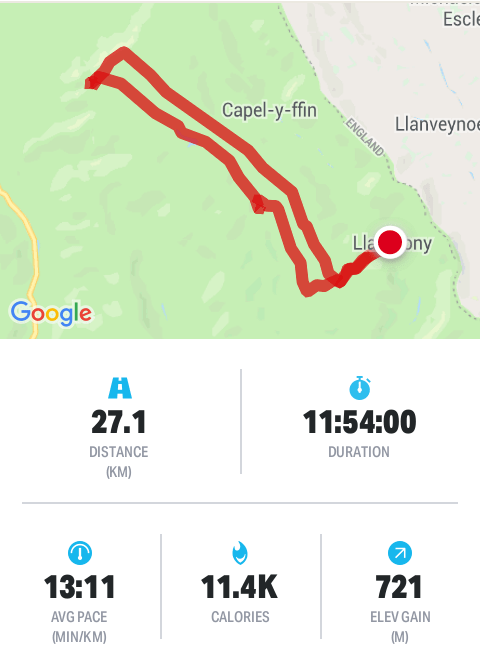
Drove round to the finishing campsite and walked up to the Bwlch next to Fan-y-big. One of my groups was there and were planning an addition to their route because they wouldn’t be out long enough. I suggested more time spent on their aim. Eventually they decided on the path NW of Cribyn. It’s a narrow ledge which should be spectacular.

Then I went up the summit to find my other group. They were visible from the Bwlch, clearly making navigation decisions so I guessed where they’d be. Sure enough, they were relaxing on the summit.

From here, I went to the summit of Cribyn, not because I needed, to just to bag it. From there to the bwlch the other side so i could re-trace the route my group 2 had taken an hour earlier. There was damage from a landslide half way along.I hoped the gold group were okay. If they weren’t, I’d find them. I didn’t.

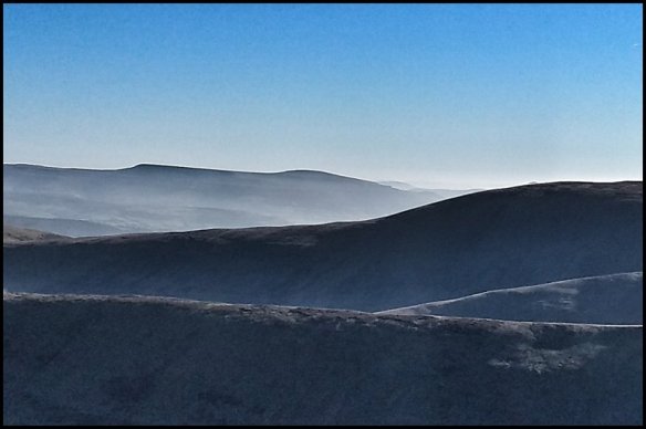
DofE 16.3: the alarm it set for 05.40 to give time to organise groups and myself. We’re relocating, so the tent has to come down. However, above blazed the stars in Orion, Gemini and Auriga. Before dawn, before breakfast, I gazed through binoculars. This was a chance to see clearly without light pollution. Sirius and all of Canis Major was visible down to the horizon. I’ve never seen it like that before. Twilight would soon show.

Back up Cribyn. Leaving the tent to dry, I set off after 3 groups who had started. The other staff reassured me that it’s okay to overtake them to man the summit.

Here they come.

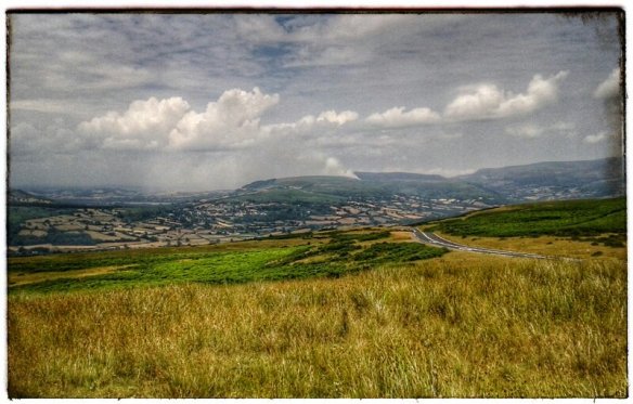
Here was another spectacular day, crystal clear and deep blue above, from the vantage point, the very top of Sugar Loaf mountain can be seen in the distant east. From here, I watched the two groups climb the north ridge. They were so thrilled to get to the top; many selfies were taken.

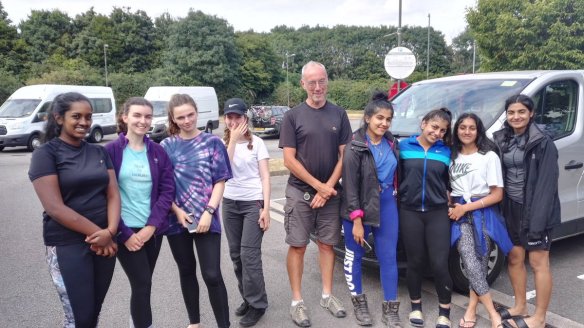
DofE 16.4: last day, a simple walk up the Taff valley. Weather was cool but bright and dry; good for us then. Debrief would be 2km from the finish to prevent a rush to board the coach. Debrief is payback, I know I get money for this job but feedback from the kids is a kind of pay. They were lovely too, grateful and charming. I got a sense that they will genuinely develop a love for the hills, their kit will be used again.

DofE 14: Yorkshire Dales.

14°C, rain and gales. Gusts up to 40mph.

14.0 Arrived about 11.30am for a Gold Qualifying expedition. The minibusses wouldn’t arrive for at least 2 hours so I went up Whenside for the fun of it. People were up there half way through the Yorkshire 3 Peaks challenge. The group at this summit were in good spirits and all stopped for a cigarette. Did they do this on each summit?

Afterwards, we spent the afternoon organising the kids and routes. I did not sleep well. Perhaps I should have stayed the night in my tent.

(Formerly) hurricane Helene struck us in the night. This morning the full force revealed itself further. Now it’s known as Storm Ali.

14.1 Tuesday: I’m managing 2 groups and each had a decent ascent onto Whernside (a 736m English mountain). The gales built up rapidly over the hours. I walked north from the Ribbleside Viaduct. The gusts grew fierce and the showers heavier. Group 1 sounds distressed on the ridge because of the wind. Pete, our asessor waited on the summit and between us, we saw both groups. All of them were quite dispondant, soaked and battered by blasts. I let them off the final summit (Blea Moor). They’re delightful kids and deserve encouragement.

14.2: Wednesday and a big storm comes. They’ve named it now: ‘Ali’. I can see it rolling in the other side of the valley, it will be here in 15mins. Trees here are thrashing like that scene in Harry Potter. 10 minutes sunshine remain while the car rocks side to side.

First rain started at 11.19am. Eventualy, both groups passed through. Group A had a pretty miserable lunchbreak in the woods during heavy rain. The others arrived in a brief sunny spell. The wind roared and we staggered drunkenly. Across the road, Open Access land flanks of Ingleborough. This is a lenghy sea of grass with shakeholes everywhere. I took off to Clapham to backtrack from the east. The climb up from “A Pennine Jouney” was fabulous. It’s a less well trodden route which is worth a trip. The gorge tapers to a narrow funnel with overhanging black cliffs and an ominous dark cave on the left.

I spent some hours on the traverse. I passed one shakehole with a tent in it, another had scrap metal. The land is pockmarked like an ancient battlefield. All the time, the rain drove on, and visibility was poor. Navigation was fine but I missed my colleague in the downpour.eventually, I dropped down via Maybury in failing light. One group was still on the moors he said. We met up hoping to walk up from Clapham. Neither of us could really understand why they were so slow. One factor is their late start time, they begain walking at 08.30. 07.30 would be a more reasonable beginning.

Finally, the rest of our staff team arrived in the minibus to rescue the four girls and with plans to get pub food for us. Today is a late one.

14.3 the wind has dropped but heavy rain is due this afternoon. routes are low level giving us time to recover.

The kids are getting better. They’re snacking more which maintains a more constant energy level. They need to drink more and start the day earlier. Last year, groups set off at 7am. If they prepare bags in the evening, and organise the stuff in tents, then the morning will happen more smoothly. There is more to expeditions than walking and pitching tents.

14.4: Pen-y-Ghent. (last day). Another storm arrives today; the morning starts chilly at 5°C and a strenghtening breeze. By lunch, heavy showers and gale force gusts to 40mph, more at height. My job was to man the checkpoint on the summit. On reaching the shoulder, before the scramble section, the wind ran full force over the pass.

The shelter at the top is just like the one at the top of Whernside, two semi-circles with seats to hide from the blast.

Two old guys arrived soon after me and we had a nice natter. Each carried big flasks of tea which from which they gave me cups. Warm tea was very welcome. To keep warm, I walked the ridge to looking for reception, or my groups. The groups came first but on the windward side of the wall. My message to suggest the downwind side never got through. Oh well, they were in good sprits even after the hailstorm.

Group Two arrived not long after, cold, wet but also contented. It was their last day, a fact that kept them going. Thats quite a lift from Tuesday when they asked about quitting. Each day, they made incremental improvements that made the harsh conditions bearable. This week is the worst DofE weather we have ever had: two named storms and yellow weather warnings.

Debrief was great in the storm shelter and all participants were obviously relieved and quite pleased with themselves.

This was a poignant time for me too. I’ve led these groups through bronze, silver and now- Gold. They even discussed which royal they’d like to receive their presentation from.

For me, I’m satisfied that I could spend tbe day on a mountain in harsh conditions and remain comfortable.

3: Breadalbane

12°C, rain, much of it heavy with brisk SW.

Moved to the Trossachs, this gives me a new area to explore and a shorter drive home than Ardnamuchan. The Ben Lawers range was recommended by the Fife couple. It may be that I don’t get onto the range of Munros immediately north of here because of the weather. Often in previous years, I have used the return journey to look for ideas for future trips. Maybe this stop will work the same.

Found a campsite on the shore of Loch Tay. This area seems more geared towards caravans and even this site is dominated by those hideous things. This place is a bit of a come-down after the fine views at the last site. Perhaps the hill-fog will lift in the morning and something exciting with appear.

3.1/ Ben Lawers and the ridge: first some stats, total 8h54mins (incl stops); total ascent 1518m, descent 1256m, distance ;

Summits: Beinn Glas, 1103m; Ben Lawers, 1214m; An Stuc, 1118m; Meall Garbh, 1118m. I skipped out Meall Greigh because of titimeme and the rain had started heavily by then.

Summits were gained quite easily, I felt fit. That dragging sleepy feeling had gone which plagued the day on Ben Hiant. Maybe I was held back by a bug or something. All of the summits were in thick hill fog and strong wind. I estimate 40mph gusts, I unfolded the poles after B. Lawers.

There was lots of geology, despite the terrible visibility. Schist was in abundance as were micro-folds. There were rocks with tight zig-zag folds as little as 6″ amplitude. I took no photos because of worries about tne effect hmudity or rain would have on tbe camera. Perhaps that’s why I got round so quickly.

The descent from the bealach at larig Innein was grassy and fairly easy. There were faint trails to follow down past an enclosure to a dam. It’s a small dam that’s part of a bigger system, presumably for collecting fresh water. These structures reminded me of those on Ben Cruachen. Burn water is collected into numbered inlets into a huge pipe that mostly runs beneath the ground. The pipe is black as is the concrete hese structures are made from. All over are rusty or white streaks from weathering. As I walked south, I played a counting game to pace out the way. This section is easy and I wanted to cover some ground quickly. Turning downhill, the track zig-zags once before I had to leave it to follow a derelict stone wall. Follow that and it leads you back to the car park. Sounds easy huh? In a way, this last leg was the hardest with deep gullys streams to cross and rough ground hidden by tussocks. That last 3 km took nearly a 2 hours. Was it the hardest or was I beginning to tire? Either way, it was a slog along long grass and heather. The trickiest bit was crossing gulleys that contain Burns which were partly hidden by bracken.

At the end car-park, a mountain rescue party arrived at the same time as me. Two women were lost in the mist, I overheard. They’d gone to B. Lawers and intended to come back the same way. They phoned for help in the An Stuc area. So they went north off the summit instead of SW. Oh dear.

2: Kilchoan in Ardnamurchan

13°C, SSE breeze but sunny now after heavy showers.

Day 1: Arrived at the most wonderful campsite. In front of me are superb views of the Sound of Mull and to the right, Mull itself. Left, I can see Ben Hiant. By morning, there were Sea Eagles perched on a small islet not far from shore. I’m told that Sea Otters live nearby too.

That’s Ben Hiant on the left, Sound of Mull in front.

Day 2: Ben Hiant, 540m. Figures- total walk time 5h 52m (including stops). Total ascent 572m and descent 587.

This is not a huge mountain so some creativity with the route was suitable. Its a complex mount with layers of gneiss, basaltic lava and dolerite. All the action happened around 60mya when the atlantic started to open up. Just as interesting was animal life today. Firstly, a wide circuit around a field of cattle and in return, red deer took wide circuits around me. He herds were small, 7 and 2 individuals. He larger herd stood near the top watching me as I ate sandwiches. Either they wanted to travel my way, or they fancied a raspberry jam butty.

By the end, I was ready for a nap. If the day was a little warmer, finding a spot on the hill for a snooze would have been perfect.

Day 3: Sanna and the Eukaryte Ring.

Two parts, first, visit the lighthouse at Point of Ardnamuchan. Surprisinly, this lighthouse marks the most westerlt place on the UK mainland. The edge of the world feeing was enhanced by the squally downpours hat struck every half hour. There is quite a nice geology and lighthouse museum on the site.

Part 2, walk from Portuairk to Sanna. Here is a string of ideal white sand beaches and smooth basalt rocks. When i got there, the whote vista was empty so that panoramic pictures should come out well. There are houses here that have money spent on them in recent years, some traditional Scottish cottages have modern attachments: charcoal wooden cladding (whatever that’s called); dark metal windows that reach high into the eves. I bet they’re second homes.

From Sanna, you get easy access to the ring dyke system. Its an almost perfect and complete circle with a breach just east of the village. I say ‘village’ but it’s no more than a loose cluster of houses on the raised beach behind dunes. There is no focus to the houses, no corner shop or a church or anything like that. Anyway, I decided to walk a little way to get a view just inside the ring. It looks loke a meteor crater, flat inside with a slight rise in the middle. I climbed up onto part of the rim to look both at the view and the rocks themselves. The rocks were grey, crystaline with large black crystals embedded. Most pieces are weathered on at least one side. I searched for one with the biggest crystals. Most are very rounded as are the outcrops which are easy to walk on.

The ring is cut, in places by deep gulleys and I decided to descend in one of these. On one side was a suitable looking pebble which I picked up. Then the oddest thing: beneath this loose precarious pebhle was an ants’ nest. This pebble covered their egg chamber. How could such an easily disturbed little stone cover the most important part of their nest? They frantically carried eggs away as I carefully replaced the little pebble back as it was.

Anyway, the north coast is very nice, fine views of the inner Hebrides and world class beaches.

I shall relocate tomorrow, I dont know to where yet.

1: Bridge of Orchy.

27°C, highest in Glasgow. Better in highlands. 0 cloud or wind.

Very long drive, too long. The M6 was closed between Preston and Lancaster. That pushed all the traffic onto local A roads which immediately stopped.

Normally, on this trip, I go to Glen Coe but it’s too late. Besides, I have an idea for some hills tomorrow, some unfinished business. I’m eyeing up Beinn Dhotaih and some other summits behind.

Friday: some Munros. Started cloudy with summits obscured. 21°C, humid and milky haze. Set off in goood time 08.30. It took an nour toreach the bealach by Beinn Dorian. From here on its off track down the glen in front and turnn north to reach the next bealach. Another turn here and head up the grassy banks of Beinn Achaladair. (1016m). On the approach was the silhouette of a couple from Fife who were very friendly, they even offered me a lift back to the car if I wanted out before Chreachan. I didnt, I have all day and sunset is still late.the summits had cleared and views of distant land was clear, if a little milky. The photos should be good with some post processing.

Beinn a Chreachain was the highlight of the day although short lived as cloud drew in. The stiles of cloud passed on both sides but didn’t release any rain. From here, the desce t has to be north east which does add considerably to the day’s milage. I tried cutting the corner in Gleann Cailliche but am still unsure whether this practice actually saves any energy; the point is to avoid dropping any more height than necessary. Eventually, another track which offers better speed but it’s short lived. There is, for no apparent reason, a turning circle at its end half way up the valley. To get back, here are 2 cols to cross which explains the high climb figure for the day.

Figures: total time 12h 42m, ascent 2047m, decent 2003m,

Heavy thundery showers are promised for Saturday so I’m moving west to the coast tomorrow. The secret to a good trip in Scotland is to escape bad weather by moving to the sea. We’ve had a very hot and dry summer and this could mark the end of it.

Old Man of Coniston

21°C white cloud and humid.

I hiked with MapMyRide+! Distance: 14.05km, time: 06:02:00, pace: 25:46min/km, speed: 2.33km/h.
http://mapmyride.com/workout/3033621601

The atmosphere dominated the day. Not today, those boring photos of blazing sun, blue sky and distant vistas. Clouds spilled over the mountain ridge like an overflowing dam.

I really like this photo, it sums up the day very well. In rthe distance is the summit of Old Man.

I met a guy who offered to take my photo and he turned out to be a good walking companion. Coincidentally he comes from the same home town as I. After a few hours, we teamed up with a Dutch couple who came out for a walk; er, without a map.

I got a QMD out of this which felt fine at the time but I felt my legs complaining this morning.

14/ Man verses Lakes: marshalling.

20°C, white cloud.

14.1: A late start means a late finish just as night is falling. It’s the problem with the tides determinig the start time for this race. The first stage was over the sands at Silverdale to Grange Over Sands where we all were briefed. The event was a marathon called Man Verses Lakes.

It’s quite differet working with adults, I’m used to children with 13 DofE trips this season. Most of the racers were grateful for my words of encouragement and jelly-babies. I gave them factual information, height to the top, remaining distance and the like.

14:2 eating breakfast, shall I climb Old Man Of Coniston? The cloud base is quite low and there has been soft drizzle overnight; but on the other hand, I have come all this way.

DofE 13.0: Hitchin.

26°C, 2/5 cloud, 0 wind.

Camped at Henlow Bridge. Not my kind of campsite but only for 1 night. Expensive too, £26 for 1 night. That’s london prices, I didn’t get to the bureau de change to get london pounds. London currency looks the same but can’t buy as much.

13.1, met the groups at about 10am in Hitchin. We went through kit checklists by way of introduction, as usual. I know the routine now, it often involves a detailed list with the boys pressing to get going. Another routine that has been steady over the last few weeks is managing the heat. Still, many boys didn’t have enough water. 2 litres is recommend, many were on 1.5. Some had rucksacks that were only 40 litres. Eventualy, off they went ln qualifying. Today’s routes are much longer, I swapped one group’s route around to make my checkpointing easier.

The sun shone fiercely, and the air hung still. It was a hot one again. This is like being in the south of France.

13.2 Day two: Both groups had a much shorter routes which resulted in a happier mood in each team. The weather was still hot and dry- reaching 28°C in the early afternoon.

I’m now typing in light rain in a service station on the M6, (quite pleasant actually). I’ve typed up the Assessor reports and am now free tirelax on the long drive home.

DofE 12: Brecon Beacons.

24°C, sunny with fair clouds, light breeze.

Back to the Beacons, with different groups this time; however, most I’ve met or taught before. Yes, it’s my old school DofE again. My job was to drive the Gold groups to their start location so they can walk to their first campsite in llanthony Priory.

Gold_2018QMHS

12.0: Monday, The problems came fairly soon.. We were instructed to drop them off and then drive to the staff campsite; later, we would checkpoint the groups. A small problem pointed to a larger problem with this scheme. The idea of Practice is to practice the training and simulate the qualifying expedition. But their training was a year ago so they were practising a skill-set they had every reason to be rusty with. Instead of driving to the staff camp, I went to the gold’s first checkpoint it was only 2.8 km away over a ridge. Neither group showed up, not even after 2 1/2 hours. Something was wrong and I had no way to contact them, nor with base. No phone signal or shortwave radio reception in this valley. My anxiety level shot up; if something happened, it would be me that has to explain my decisions to the judge.

I decided to drive off and find better reception. I caught Group 1 over the radio who could relay messages to Group A over the ridge. Bothgroups had made mistakes in woodland. They’ve done this before. Remember when this group needed rescuing in the dark? Here they were again, going the wrong way in woodland, again.

I decided to drive back to base camp since I was out solo and worried. Was I carrying paperwork that the Silver groups needed etcetera. Going back felt wrong too, my instinct said that I can leave them but should have contact every two hours. I’ve brought 8 teenage girls well over 100 miles from their school and dropped them in a field unfamiliar to them. What if something happened? I tried the radio once more, then Aneeka’s voice! She gave a location, and she could relay messages from the other group on the hill that I could not directly hear. Contact!

Relieved but not satisfied, I drove away to base and the other staff. I raised my concerns around the theme that our duty of care is the same as for year 9s’. As a staff decision, my plan won the debate…

12.2 Tuesday: . So Today, I walked most of their stage to teach navigation to the higher Gold level carrying a list of skills to try out. My total walk time was just shy of 11 hours including the return walk. We covered many techniques, pacing, bearings, and others. At the north end, the ridges opened into a plateau so I left the groups at a trig point there to make their descents. One group took longer because their nav. decision required more reading of the contours. The other group chickened-out of cutting the corner over grassland, “what if we get lost?”. They seen nervous about walking on the compass. Eventually, they went from the trig-point.

Here, the second part of my day started. I picked one group’s route and followed it back to the minibus. I did discover some tricky navigation points such as woodland and a path that started in dense bracken. In an ideal world, we leaders would walk the kids’ routes beforehand. Thus, it turned into A Long Day; I got back to the bus at 21.15.

Look at that, 11,400 calories in one walk, one day. I didn’t even feel that tired. That means it was mostly fat burning rather than sugars.

Sitting in the grass were the Silver practice groups, they were in low spirits and looking rather shocked.. Exhaustion, blisters and excessive distance brought on by gross errors in nav.. Their mistakes had added 5km to their walk. Their instructor, in despair, moved them back in the minibus to resume the route on a correct course only to see them wander off in error again. What’s going on.

12.3, Wednesday, today’s route over the mountain meant there were fewer places to set up checkpoints. Still, I want contact every 2 hours, though a position fix by text will do. I didn’t get such a fix for over 4 restless hours. Faint female voices did echo around the valley in the humid, still air. Then the radio crackled and though unintelligible at first, the tone was enough to make voices recognisable.

I have a particular affinity with these groups; it was they who needed rescuing on Gradbach Woods a few years ago when they became benighted. I’ve posted about that day here years ago. Eventually, my colleague radioed to say they arrived at the minibus while I was patrolling the hill opposite looking for them. Actually, they were in good spirits, the new girl E in particular had taken control and pushed them on. What a fabulous kid, she had the most horrific looking blister but determination enough to press on regardless and kept spirits up amongst the others.

12.4, last day, a Thursday. Still roaring hot, we could see fires on one of the mountains. Today’s routes take them along hills to the south, limestone country. Qualifying exped will be in the Yorkshire Dales. Here is some taster of the ground they will encounter up north. Soldiers were on manouvers which was funny when one ran out in the road by us, looked at a footlath sign and ran away again. He carried a rifle daubed with fluorescent orange. It was the way he ran that looked comical.

DofE 11.0: Cotswold hills.

28°C, no wind and the prospect of 30° tomorrow, close feeling too.

Working for a provider that’s new to me: BXM. It’s not too far to drive here, but for the first part of the M5 which was very slow..

11.1: day one, quite a lot to get used to but the people are excellent. They’re friendly and enthusiastic, I hope to make a good impression. The kids seem young but they’re pleasent enough. I have two groups to manage but this time we chose them by the similarity of their routes and we have two groups each to manage. The top temperature today is very high, probably 30°C.

11.2: My groups got up at a reasonable reasonable time despite refusing to last evening.

The day went well and grew hot. Tarmac melted in places. Our response is to encourage groups to slow down, we aimed for 2kph. And we offered water at every opportunity.

Look at these! They’re thistles, not a variety seen us north.