2°C, sunny with a layer of hailstones.
This is one of my Covid-19 recovery walks. The roads are too icy for cycling this week but I’m itching to get the bike out and can’t – it’s not safe yet.

2°C, sunny with a layer of hailstones.
This is one of my Covid-19 recovery walks. The roads are too icy for cycling this week but I’m itching to get the bike out and can’t – it’s not safe yet.
2°C white cloud and strong E. Windchill very significant.
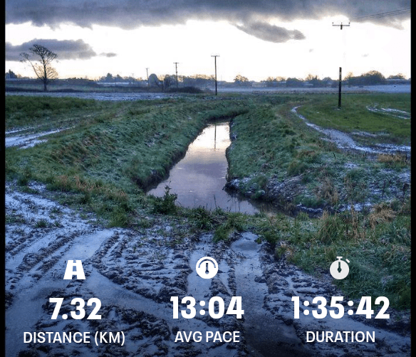
I hiked with MapMyRide+! Distance: 12.95km, time: 02:27:16, pace: 11:22min/km, speed: 5.28km/h.
http://mapmyride.com/workout/2740750153
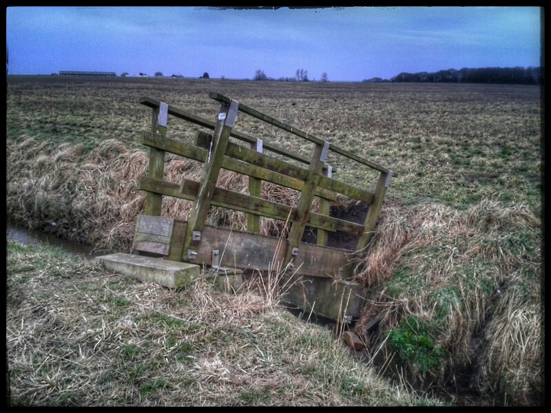
It looks as though it’s about to drop into the water.

Lancashire has a crack in it.
There are rows of these grooves, probably cut to prevent flooding in the middle of these very flat fields.
All day, that wind was a feature on this open route. Some sections were sheltered but not many. They provided some respite and reassured of in my choice of clothing. I wore the same as the Ainsdale dune route a few da p ago when it was a good 4°C colder. Today felt colder. Feeling slightly cold for a long time takes a very long time to warm up again. A factor to consider for ML assessment this summer.
Creag a’Mhain, (m), 947m,
Druim Shionnach (m), 987m;
Aonach air Crith, (m), 1021m;
Maol Chin-dearg, (m), 981m;
Sgurr an Doire Leatham, (m), 1010m;
Started with cloud at 800m with some breaks. After tricky path finding up Drochaid an Ullit Ghubhais it got easier, though steep. Once on the ridge, paths were easy to find despite no visibility. Concentration was needed to keep a track on location. Ahead lay a string of summits and bealachs. With visibility no more than 30m, other techniques were necessary to keep your position in mind. At 12.30, I pulled the storm-bivvy bag out and climbed in to read the map and eat sandwiches. These things are amazingly warm, even by myself.
On the next summit, a guy appeared out of the mist heading my way. He was James, a real Munro bagger. He had 90 odd and was keen to get as many as possible today. He suggested we walk the whole ridge together to his car and he could drop me back at Cluanie Inn. That’s not much more than my planned walk and I’d get 7 munros ‘ticked off’.

Part of the ridge, from the road.
Finally, the skies started to break on approach to the last climb. The bonus munro would be free of hill fog. Better than that, the light sharpened revealing fine views south into the deep Glen and even out to sea. Skye could be seen and possibly, Rum.
Feeling tired and thirsty, I hoped for an easy descent. But no, the rounded boulders underfoot would require concentration all the way down from 900m to the river. On another day, that would have been fun. I will have to come back.
16°C, woke to rain, brighter by lunch.
It’s a shame to pack the tent away wet. Once decamped, a visit to Caffi Gwynant is the obvious thing to do.
As I have discussed here before, I have a fascination for the Migneint. It’s a plateau (which was the centre of an ice sheet in glacial times). A rolling area of grasslands cut by meandering rivers. Last June, I checked out the start of a walk to the bothy near Arenig Fach.
The route started tricky, but is easy to navigate later. Strangely, the marked footpath deviates from the track on the map, but nothing was apparent on the ground. Simply walk along the track then!

This a fairly high altitude area, though it doesn’t look like that while there. These hills are between 400-500m, as high as the ridge I used for the last wild-camp. One clue was the fresh, cooler air.
The bothy was fairly typical, perhaps a little rougher than others. There was a newspaper from the 5th June on the table. The place was dirty and had few sleeping areas. Outside, the sides obviously used it for shelter although the door was well barricaded against them.
Not a very inviting place to stay, I’d prefer a tent. However, if you want a bad weather shelter, or you’re travelling light, this could be a solution. I would clean the place first thought.
20°C, building breeze, full sun.
Duke of Edinburgh practice expedition. There were groups this year, and a chance to use the recent training. First day was an 8 mile walk. As always, the kids’ stamina was a serious limitation, though this year, the kids seemed younger. Their fitness remains almost as low as possible, their resilience was equally weak.
However, at least I enjoyed myself. The weather was perfect and early summer was in full glory. Fields were ablaze with buttercups and all the other summer meadow flowers.
Kids frequently asked how far is it now. My answer was always look at the map and you can tell me! One persisted, add said “why don’t you just tell us?”. Because I will not do your thinking for you.

I got home very tired. Although it was only one night, I had no control over sleeping times. I bedded down after 11pm, but got up at the normal time.
Over the years, I have tried to crystallise my thoughts about the relationship between tiredness and perception.
Hiking is a rich aesthetic experience, all the senses, are invoked. Internally, I can almost feel my mind draining of the detritus it collects while at work. There, I am surrounded by voices and commotion of dozens of children at once. I need time to clear all that bilge from my head. On the other hand, in pours the experience of being out there.
That experience is altered by the building physical exhaustion of walking. For most of the daylight hours, I walk and walk.
Consider the way you listen to music on those occasions when you are half asleep. Teetering on the edge of sleep or even dipping in and out, you can still follow the soundscape. A rare state of mind.
Camping near a babbling stream is soothing. As you fall asleep, there is a time when your mind switches off your ears. Sometimes it switches back several times, an effect that can catch your attention. Peaceful.
2 days of warm sun, and now- thunder.
First DofE trip camping trip of the year. Sun is strong, and pollen dense. Day two was remote supervision, and for a change, there was a lot to do.

Worcestershire is a very attractive county. Britain is in full bloom so fields are blazing yellow with buttercups and all the rest.
Young cattle were pleased to have visitors to their fields. They all came in our direction. A herd must weigh in over 10 tonnes, I was nervous. I turned to face them, hands on hips and in unison- they all did a u-turn. This gave my group of teenagers time to clamber over the stile.
|~~~~~~~o_o~~~~~~~|
Posted from a mobile.
4C, SW brisk with heavy showers.
DofE- staff training day. This was a re-newal of our navigation qualification. For us, a nice walk around the limestone landscape of northern Staffordshire.
The next stage is a national award, this one cannot be used outside Walsall jurisdiction. A national award is more use for those of up when want to move on. I think he called it the low-life assessment.

Only problem was nagging aches from that long standing Achilles tendon problem. Every time I think it is healed, it comes back. Frustrating.
|~~~~~~~o_o~~~~~~~|
Posted from a mobile.
14°C, drizzly showers,
Last Monroe of the trip. Not a difficult climb by any means. It was interesting in a few specific ways.
1, vegetation- very mossy on the top: perhaps this top is almost always in cloud. The moss was just like the stuff I find in the gutters at home. It filled the gaps between bolders but did make them rather slippery. Although not as bad as black mosses, it still requires a change of approach.
2, Cruachan is a mountain that has been turned into a massive hydro-electric station. It can pump water up into the lake to use later in time of high demand on the national grid. More interestingly, it also draws water from Eunaich through tunnels. It can collect water directly from streams via small dams then channel them through the tunnels that run deep below the ground, right under the mountain. It was one of these tunnel entrances that fascinated me.
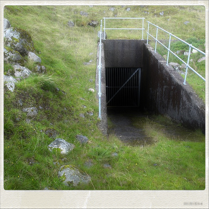
Tarkovsky would have recognised them. You’ll see what I mean when I can upload some pictures.
I found this place rather spooky. Looking into the tunnel is looking at an endless inky blackness that gurgles and thunders an deep mix of sounds that makes the mountain seem alive.
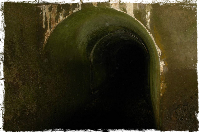
Through the gate…
20°C, clear tanning sky.
Practice Expedition: three score and eight walked over calm Worcestershire farmlands. I let one group of 14 year old girls. I say led because actually I was training them to follow a course on the map.
Lost geographer: there were four groups following our route. The first we didn’t see, apart from their footprints. the other two were ahead of us because my group took so many breaks. We stopped for a sit-down break within the first mile. Not a good start. Later though, we could see another group heading south along a field boundary, the general heading should have been east. then they turned back which lead them on a course to intercept us. They were lead by a geography teacher. Oh dear.
The mud-foot incident. Another break and this one included a pee-stop. the first went round to the next field out of sight while we ate sandwiches. she came back with a huge glob of clay-mud entirely covering one boot & lower leg. A quiet girl said ” that looks so wrong”. That’s it, I had to turn my back, I lost it unable to fight back the convulsions of laughter. I stifled them, but that made it worse.
Cider apple orchards: Had a long and interesting chat with apple farmers in a large Bulmer’s apple orchard. I heard all about how the trees are harvested, the bees and Strongbow Cider. They let the group fill up water bottles and we pressed on. Water was a problem in the heat, with most of the girls overloaded with badly packed rucksacks and unnecessary provisions. they have some to learn.
Paradise: Holt Wood lies in the most beguiling ocean of grass, meadow-lands blazing with buttercups nodding in the soft breeze. Each flower eagerly stretched towards the sun. I was elated, the air, the sun and the colours. As I walked, wistful and wide-eyed the girls did grumble. They were really very grumpy by then which seemed to spread amongst them like a contagion. None of that intruded on my thoughts, the place was utterly beautiful. I as in love with it all.
The lost geographers returned from another mis-read of the map. Better take over then, and they seemed relieved. I did a number of recces to find crossings, stiles and gates in the overgrown hedgerows. leter, I did make one mistake on the final 2km and took them up a hill 3/4 km south of the one we needed to make the descent to the camp. After another recce, where I found that the electric fences were live, I plotted a short-cut route. The short-cut was no good though, because it would take us across a field of tall grass, probably wheat. I was not going to let the teenagers trample crops down so we returned to the lane. That only added about 1/2 km to the route, they groaned collectively
The last km produced the best quote of the day for me. I trotted passed the group to put myself on the front before the final turning and one piped up: “Sir, don’t you ever get tired?”.
It was now 20.00 and still sunny.
Nope, not really, not on a walk like this anyway.
Anyway, to conclude, the kids did brighten up after food. after fussing with their efforts to make camp, I put my own tent up at about 21.30. Food by 22.30. Bed by 23.45.
-3 to +9, clear blue.
Crossed the ridge from south to North. Walked for 8½ hours with a few breaks not counting photo stops. Most of it was on snow. A new experience for me, the technique seems to be – dig your heels in on the way down. There were few of The ice slides I had feared but I did change the route. It’s a bit like walking on soft sand, except that the support is less predictable. Sometimes the snow supports your weight, sometimes your foot plunges in deep. Deep enough to reach your bum a few times.